 Anyway, truth of the matter is that I was not really inside the infamous Bermuda Triangle but rather on the Northern edge.
 The Bermuda Triangle is usually defined as the area in between Bermuda, Miami and San Juan, Puerto Rico. Consequently, coming from the North West I just skimmed the tip of the triangle.
Anyway, I have already been at least five times in the past deep inside this mysterious area and I always managed to come out of it...
 .
.The most historically relevant sinking was the one of the Sea Venture. The ill-fated Sea Venture was aimed for Jamestown, Virginia in 1609 to bring supplies and new leadership when it encountered a hurricane, got lost and somewhat ended up into the reefs of the uninhabited archipelago. Most of the sailors were saved during the wreckage and they rebuilt two sister-ships during the Spring of the following year. The Deliverance and Patience eventually reached Jamestown in 1610.

 British Territory
Queen Elisabeth II is still the final authority here and a Governor coming from the United Kingdom is appointed to Bermuda. However, the islands are factually independent.
Bermuda
Well, the so-called bermuda is considered formal dressing here and the governor actually wears it. To be considered formal, the bermuda shall be worn two inches above the knees with knee socks and shoes. Sorry no flip-flop in front of Her Majesty...
.
Other visible remnants of the British time is the left driving as well as the Anglican church. The left driving might be the reason rental-cars are banned from the islands. Too many American and Canadian tourists that could potentially mess up with the left driving techniques in those not so wide and winding roads... And I believe this is great. Most of the things are within walking distance anyway and for those really wishing to travel all around the islands, there is an efficient bus and ferry transportation system (that I did abuse with my four day unlimited pass...). .

.
The 1609 settlement of British citizens led by Somers established the first recorded settlement in Bermuda in the site of St George. St George remained untouched by the economic boom of Hamilton and looks as if it had been frozen in time. Most of the buildings in St George were designed between the 17th and 19th century. No power lines, no telephone lines there, everything is underground. St George is now a UNESCO World Heritage Site.
.

.

The unfinished Church lies in the height of St George. A typical Anglican church as might be inferred from the architecture.
If it is believed that the islands have volcanic origins, then the tip of the now extinct volcano is believed to be 120 feet underwater. It most certainly emerged from water at a time when sea level were lower. Coral reefs have built on it and the ground is now mostly made of limestone. Right in the center of the main island, some caves with stalagmites and stalactites may be found. Stalactites and stalagmites grows from the deposition of calcium carbonates and other minerals over time. .

Crystal Cave
Crystal Cave lies 120 feet under ground exactly at sea level. The water seen in the picture comes from the sea through a network of natural canals. The upper two inches of water is made of fresh water dripping from stalactites whereas the water below is plain salty sea water.
.
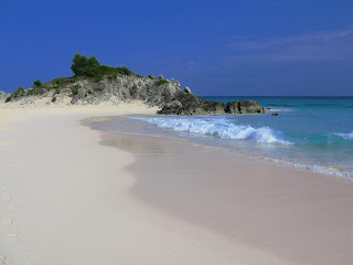
One of the highlight of my visit to Bermuda was those pink-sand beaches. Bermuda is supposed to be famous for its pink sand. The distinctive color of Bermuda's sand is due to a single-celled animal called a foram, which grows in profusion on the underside of rocks. These animals have bright red skeletons, which when the foram dies, are eroded by the waves and mixed with the other matter that makes up Bermuda's sand to give the sand a pinkish hue.

 Royal Dockyards on the left, Hamilton in the center and St George in the distance behind.
A short video of the trip to Bermuda is also available here. Enjoy !!!
.


No comments:
Post a Comment